|
|
|||||||||||||||||
| Point ID: 5462 | Downloads | Plots | Site Data | Code: 05LA002 |
|
|
|||||||||||||||||
| Download | |
|---|---|
| Site Descriptor Information | Site Time Series Data |
| Link to all available data | |
| View: | Time Series | All |
| Units: | mm |
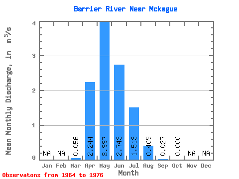
| Statistic | Jan | Feb | Mar | Apr | May | Jun | Jul | Aug | Sep | Oct | Nov | Dec | Annual |
|---|---|---|---|---|---|---|---|---|---|---|---|---|---|
| Mean | 0.06 | 2.24 | 4.00 | 2.74 | 1.51 | 0.41 | 0.03 | 0.00 | |||||
| Standard Deviation | 0.08 | 0.88 | 2.61 | 1.48 | 0.73 | 0.36 | 0.04 | 0.00 | |||||
| Min | 0.00 | 1.08 | 1.88 | 1.61 | 0.95 | 0.04 | 0.00 | 0.00 | |||||
| Max | 0.11 | 3.88 | 7.71 | 4.76 | 2.55 | 0.76 | 0.05 | 0.00 | |||||
| Coefficient of Variation | 1.41 | 0.39 | 0.65 | 0.54 | 0.48 | 0.88 | 1.41 |
 Return to R-Arctic Net Home Page