|
|
|||||||||||||||||
| Point ID: 5453 | Downloads | Plots | Site Data | Code: 05KH007 |
|
|
|||||||||||||||||
| Download | |
|---|---|
| Site Descriptor Information | Site Time Series Data |
| Link to all available data | |
| View: | Time Series | All |
| Units: | mm |
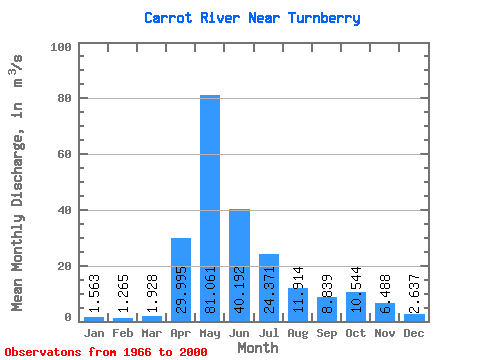
| Statistic | Jan | Feb | Mar | Apr | May | Jun | Jul | Aug | Sep | Oct | Nov | Dec | Annual |
|---|---|---|---|---|---|---|---|---|---|---|---|---|---|
| Mean | 1.56 | 1.27 | 1.93 | 30.00 | 81.06 | 40.19 | 24.37 | 11.91 | 8.84 | 10.54 | 6.49 | 2.64 | 18.14 |
| Standard Deviation | 0.71 | 0.53 | 1.38 | 15.63 | 62.19 | 33.21 | 20.54 | 12.20 | 7.40 | 7.69 | 4.77 | 1.47 | 8.89 |
| Min | 0.63 | 0.36 | 0.34 | 3.62 | 6.05 | 4.28 | 2.64 | 1.60 | 0.95 | 1.38 | 1.16 | 0.42 | 5.44 |
| Max | 3.20 | 2.59 | 7.46 | 70.70 | 226.00 | 137.00 | 87.00 | 69.90 | 35.80 | 38.20 | 19.90 | 6.27 | 37.80 |
| Coefficient of Variation | 0.45 | 0.42 | 0.72 | 0.52 | 0.77 | 0.83 | 0.84 | 1.02 | 0.84 | 0.73 | 0.73 | 0.56 | 0.49 |
 Return to R-Arctic Net Home Page