|
|
|||||||||||||||||
| Point ID: 5451 | Downloads | Plots | Site Data | Code: 05KG002 |
|
|
|||||||||||||||||
| Download | |
|---|---|
| Site Descriptor Information | Site Time Series Data |
| Link to all available data | |
| View: | Time Series | All |
| Units: | mm |
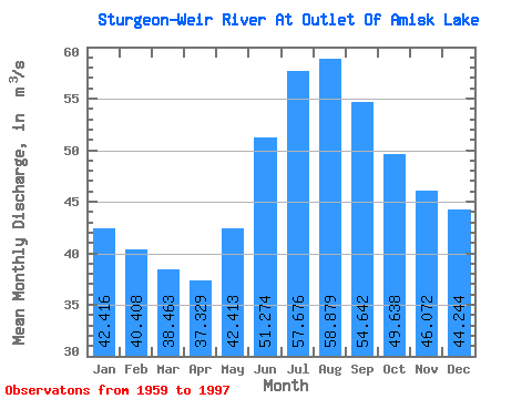
| Statistic | Jan | Feb | Mar | Apr | May | Jun | Jul | Aug | Sep | Oct | Nov | Dec | Annual |
|---|---|---|---|---|---|---|---|---|---|---|---|---|---|
| Mean | 42.42 | 40.41 | 38.46 | 37.33 | 42.41 | 51.27 | 57.68 | 58.88 | 54.64 | 49.64 | 46.07 | 44.24 | 46.91 |
| Standard Deviation | 17.80 | 15.30 | 13.22 | 12.25 | 14.30 | 20.93 | 28.69 | 33.46 | 34.51 | 29.84 | 25.30 | 21.14 | 20.29 |
| Min | 15.50 | 16.80 | 17.20 | 16.90 | 19.10 | 20.80 | 23.10 | 18.60 | 16.70 | 13.50 | 14.10 | 14.70 | 17.96 |
| Max | 95.10 | 79.60 | 68.10 | 64.00 | 74.40 | 109.00 | 153.00 | 178.00 | 203.00 | 173.00 | 141.00 | 115.00 | 107.47 |
| Coefficient of Variation | 0.42 | 0.38 | 0.34 | 0.33 | 0.34 | 0.41 | 0.50 | 0.57 | 0.63 | 0.60 | 0.55 | 0.48 | 0.43 |
 Return to R-Arctic Net Home Page