|
|
|||||||||||||||||
| Point ID: 5450 | Downloads | Plots | Site Data | Code: 05KF001 |
|
|
|||||||||||||||||
| Download | |
|---|---|
| Site Descriptor Information | Site Time Series Data |
| Link to all available data | |
| View: | Time Series | All |
| Units: | mm |
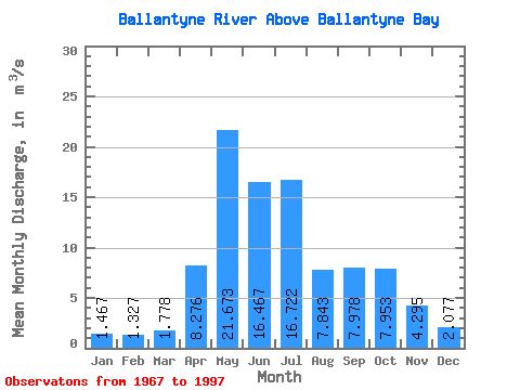
| Statistic | Jan | Feb | Mar | Apr | May | Jun | Jul | Aug | Sep | Oct | Nov | Dec | Annual |
|---|---|---|---|---|---|---|---|---|---|---|---|---|---|
| Mean | 1.47 | 1.33 | 1.78 | 8.28 | 21.67 | 16.47 | 16.72 | 7.84 | 7.98 | 7.95 | 4.29 | 2.08 | 8.21 |
| Standard Deviation | 0.71 | 0.76 | 1.19 | 5.41 | 10.70 | 10.51 | 24.36 | 5.38 | 5.66 | 4.01 | 2.41 | 1.13 | 4.12 |
| Min | 0.24 | 0.16 | 0.20 | 1.28 | 4.61 | 2.68 | 2.55 | 1.49 | 1.40 | 2.08 | 0.84 | 0.38 | 3.47 |
| Max | 3.09 | 2.85 | 5.68 | 23.00 | 48.40 | 54.20 | 134.00 | 19.70 | 22.70 | 16.40 | 9.97 | 5.29 | 22.25 |
| Coefficient of Variation | 0.49 | 0.57 | 0.67 | 0.65 | 0.49 | 0.64 | 1.46 | 0.69 | 0.71 | 0.50 | 0.56 | 0.54 | 0.50 |
 Return to R-Arctic Net Home Page