|
|
|||||||||||||||||
| Point ID: 5447 | Downloads | Plots | Site Data | Code: 05KE006 |
|
|
|||||||||||||||||
| Download | |
|---|---|
| Site Descriptor Information | Site Time Series Data |
| Link to all available data | |
| View: | Time Series | All |
| Units: | mm |
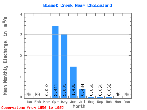
| Statistic | Jan | Feb | Mar | Apr | May | Jun | Jul | Aug | Sep | Oct | Nov | Dec | Annual |
|---|---|---|---|---|---|---|---|---|---|---|---|---|---|
| Mean | 0.00 | 3.41 | 3.01 | 1.49 | 0.43 | 0.05 | 0.05 | 0.07 | |||||
| Standard Deviation | 0.01 | 3.58 | 3.57 | 1.88 | 0.61 | 0.07 | 0.06 | 0.09 | |||||
| Min | 0.00 | 0.00 | 0.00 | 0.00 | 0.00 | 0.00 | 0.00 | 0.00 | |||||
| Max | 0.02 | 14.30 | 11.60 | 4.94 | 2.10 | 0.21 | 0.17 | 0.21 | |||||
| Coefficient of Variation | 2.82 | 1.05 | 1.19 | 1.26 | 1.40 | 1.42 | 1.26 | 1.31 |
 Return to R-Arctic Net Home Page