|
|
|||||||||||||||||
| Point ID: 5442 | Downloads | Plots | Site Data | Other Close Sites | Code: 05KD005 |
|
|
|||||||||||||||||
| Download | |
|---|---|
| Site Descriptor Information | Site Time Series Data |
| Link to all available data | |
| View: | Time Series | All |
| Units: | mm |
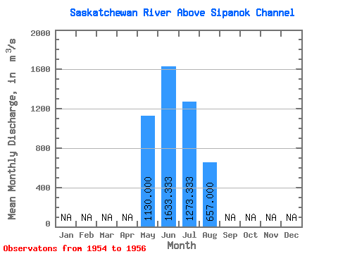
| Statistic | Jan | Feb | Mar | Apr | May | Jun | Jul | Aug | Sep | Oct | Nov | Dec | Annual |
|---|---|---|---|---|---|---|---|---|---|---|---|---|---|
| Mean | 1130.00 | 1633.33 | 1273.33 | 657.00 | |||||||||
| Standard Deviation | 352.75 | 190.09 | |||||||||||
| Min | 1130.00 | 1410.00 | 1080.00 | 657.00 | |||||||||
| Max | 1130.00 | 2040.00 | 1460.00 | 657.00 | |||||||||
| Coefficient of Variation | 0.22 | 0.15 |
| Other Close Sites | ||||||
|---|---|---|---|---|---|---|
| PointID | Latitude | Longitude | Drainage Area | Source | Name | |
| 5441 | "SASKATCHEWAN RIVER BELOW TOBIN LAKE" | 53.70 | 912473 | Hydat | ||
 Return to R-Arctic Net Home Page