|
|
|||||||||||||||||
| Point ID: 5434 | Downloads | Plots | Site Data | Code: 05KB011 |
|
|
|||||||||||||||||
| Download | |
|---|---|
| Site Descriptor Information | Site Time Series Data |
| Link to all available data | |
| View: | Time Series | All |
| Units: | mm |
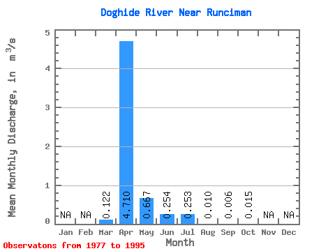
| Statistic | Jan | Feb | Mar | Apr | May | Jun | Jul | Aug | Sep | Oct | Nov | Dec | Annual |
|---|---|---|---|---|---|---|---|---|---|---|---|---|---|
| Mean | 0.12 | 4.71 | 0.67 | 0.25 | 0.25 | 0.01 | 0.01 | 0.01 | |||||
| Standard Deviation | 0.24 | 4.36 | 1.33 | 0.66 | 0.94 | 0.03 | 0.02 | 0.02 | |||||
| Min | 0.00 | 0.16 | 0.01 | 0.00 | 0.00 | 0.00 | 0.00 | 0.00 | |||||
| Max | 0.93 | 13.90 | 5.91 | 2.77 | 4.14 | 0.14 | 0.10 | 0.09 | |||||
| Coefficient of Variation | 1.94 | 0.93 | 2.00 | 2.59 | 3.73 | 3.43 | 3.76 | 1.49 |
 Return to R-Arctic Net Home Page