|
|
|||||||||||||||||
| Point ID: 5428 | Downloads | Plots | Site Data | Code: 05KB005 |
|
|
|||||||||||||||||
| Download | |
|---|---|
| Site Descriptor Information | Site Time Series Data |
| Link to all available data | |
| View: | Time Series | All |
| Units: | mm |
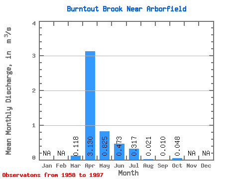
| Statistic | Jan | Feb | Mar | Apr | May | Jun | Jul | Aug | Sep | Oct | Nov | Dec | Annual |
|---|---|---|---|---|---|---|---|---|---|---|---|---|---|
| Mean | 0.12 | 3.13 | 0.82 | 0.47 | 0.32 | 0.02 | 0.01 | 0.05 | |||||
| Standard Deviation | 0.22 | 2.37 | 1.12 | 0.84 | 0.86 | 0.06 | 0.04 | 0.08 | |||||
| Min | 0.00 | 0.03 | 0.00 | 0.00 | 0.00 | 0.00 | 0.00 | 0.00 | |||||
| Max | 1.02 | 8.71 | 5.06 | 3.18 | 4.03 | 0.29 | 0.23 | 0.34 | |||||
| Coefficient of Variation | 1.87 | 0.76 | 1.35 | 1.78 | 2.71 | 2.71 | 4.03 | 1.67 |
 Return to R-Arctic Net Home Page