|
|
|||||||||||||||||
| Point ID: 5423 | Downloads | Plots | Site Data | Code: 05KA009 |
|
|
|||||||||||||||||
| Download | |
|---|---|
| Site Descriptor Information | Site Time Series Data |
| Link to all available data | |
| View: | Time Series | All |
| Units: | mm |
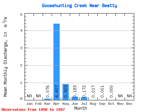
| Statistic | Jan | Feb | Mar | Apr | May | Jun | Jul | Aug | Sep | Oct | Nov | Dec | Annual |
|---|---|---|---|---|---|---|---|---|---|---|---|---|---|
| Mean | 0.08 | 4.41 | 0.92 | 0.18 | 0.17 | 0.02 | 0.00 | 0.00 | |||||
| Standard Deviation | 0.23 | 4.42 | 1.77 | 0.39 | 0.68 | 0.04 | 0.00 | 0.00 | |||||
| Min | 0.00 | 0.02 | 0.00 | 0.00 | 0.00 | 0.00 | 0.00 | 0.00 | |||||
| Max | 1.00 | 16.60 | 7.28 | 1.84 | 3.91 | 0.17 | 0.02 | 0.00 | |||||
| Coefficient of Variation | 3.09 | 1.00 | 1.91 | 2.13 | 3.95 | 2.36 | 3.89 | 5.75 |
 Return to R-Arctic Net Home Page