|
|
|||||||||||||||||
| Point ID: 5407 | Downloads | Plots | Site Data | Code: 05JM001 |
|
|
|||||||||||||||||
| Download | |
|---|---|
| Site Descriptor Information | Site Time Series Data |
| Link to all available data | |
| View: | Time Series | All |
| Units: | mm |
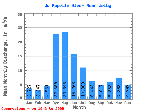
| Statistic | Jan | Feb | Mar | Apr | May | Jun | Jul | Aug | Sep | Oct | Nov | Dec | Annual |
|---|---|---|---|---|---|---|---|---|---|---|---|---|---|
| Mean | 3.73 | 3.25 | 4.56 | 22.69 | 23.34 | 15.76 | 10.97 | 6.44 | 5.02 | 5.86 | 7.28 | 5.00 | 9.01 |
| Standard Deviation | 2.62 | 2.25 | 3.42 | 23.50 | 30.34 | 18.63 | 14.99 | 9.18 | 6.70 | 5.42 | 4.23 | 3.06 | 7.61 |
| Min | 0.13 | 0.26 | 0.60 | 1.22 | 0.60 | 0.37 | 0.19 | 0.08 | 0.00 | 0.00 | 0.30 | 0.13 | 0.77 |
| Max | 9.61 | 8.61 | 15.00 | 106.00 | 141.00 | 68.60 | 74.10 | 38.30 | 27.40 | 21.00 | 16.20 | 12.60 | 26.59 |
| Coefficient of Variation | 0.70 | 0.69 | 0.75 | 1.04 | 1.30 | 1.18 | 1.37 | 1.43 | 1.33 | 0.93 | 0.58 | 0.61 | 0.84 |
 Return to R-Arctic Net Home Page