|
|
|||||||||||||||||
| Point ID: 5393 | Downloads | Plots | Site Data | Code: 05JJ005 |
|
|
|||||||||||||||||
| Download | |
|---|---|
| Site Descriptor Information | Site Time Series Data |
| Link to all available data | |
| View: | Time Series | All |
| Units: | mm |
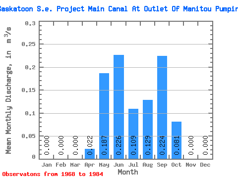
| Statistic | Jan | Feb | Mar | Apr | May | Jun | Jul | Aug | Sep | Oct | Nov | Dec | Annual |
|---|---|---|---|---|---|---|---|---|---|---|---|---|---|
| Mean | 0.00 | 0.00 | 0.00 | 0.02 | 0.19 | 0.23 | 0.11 | 0.13 | 0.22 | 0.08 | 0.00 | 0.00 | 0.00 |
| Standard Deviation | 0.00 | 0.07 | 0.23 | 0.22 | 0.20 | 0.21 | 0.26 | 0.16 | 0.00 | ||||
| Min | 0.00 | 0.00 | 0.00 | 0.00 | 0.00 | 0.00 | 0.00 | 0.00 | 0.00 | 0.00 | 0.00 | 0.00 | 0.00 |
| Max | 0.00 | 0.00 | 0.00 | 0.24 | 0.61 | 0.53 | 0.54 | 0.57 | 0.62 | 0.59 | 0.00 | 0.00 | 0.00 |
| Coefficient of Variation | 3.32 | 1.24 | 0.96 | 1.83 | 1.60 | 1.14 | 2.01 |
 Return to R-Arctic Net Home Page