|
|
|||||||||||||||||
| Point ID: 538 | Downloads | Plots | Site Data | Code: 05FA022 |
|
|
|||||||||||||||||
| Download | |
|---|---|
| Site Descriptor Information | Site Time Series Data |
| Link to all available data | |
| View: | Time Series | All |
| Units: | mm |
| Statistic | Jan | Feb | Mar | Apr | May | Jun | Jul | Aug | Sep | Oct | Nov | Dec | Annual |
|---|---|---|---|---|---|---|---|---|---|---|---|---|---|
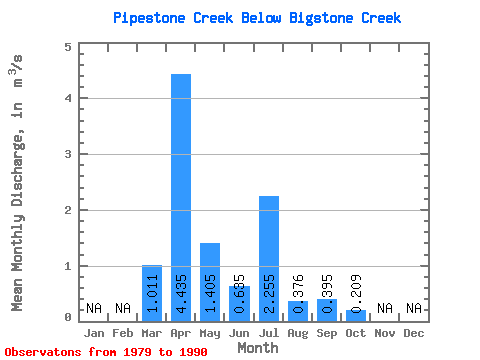
| Mean | 1.01 | 4.43 | 1.41 | 0.64 | 2.25 | 0.38 | 0.40 | 0.21 | |||||
| Standard Deviation | 1.21 | 3.60 | 1.61 | 0.61 | 3.40 | 0.46 | 0.99 | 0.37 | |||||
| Min | 0.00 | 0.19 | 0.07 | 0.03 | 0.04 | 0.01 | 0.02 | 0.02 | |||||
| Max | 3.34 | 11.60 | 5.86 | 2.01 | 9.29 | 1.24 | 3.36 | 1.31 | |||||
| Coefficient of Variation | 1.20 | 0.81 | 1.15 | 0.96 | 1.51 | 1.23 | 2.50 | 1.79 |
 Return to R-Arctic Net Home Page