|
|
|||||||||||||||||
| Point ID: 5378 | Downloads | Plots | Site Data | Code: 05JG004 |
|
|
|||||||||||||||||
| Download | |
|---|---|
| Site Descriptor Information | Site Time Series Data |
| Link to all available data | |
| View: | Time Series | All |
| Units: | mm |
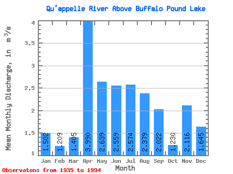
| Statistic | Jan | Feb | Mar | Apr | May | Jun | Jul | Aug | Sep | Oct | Nov | Dec | Annual |
|---|---|---|---|---|---|---|---|---|---|---|---|---|---|
| Mean | 1.50 | 1.21 | 1.41 | 3.99 | 2.64 | 2.56 | 2.57 | 2.38 | 2.02 | 1.23 | 2.12 | 1.65 | 2.91 |
| Standard Deviation | 1.01 | 0.57 | 1.70 | 4.17 | 3.52 | 3.67 | 3.18 | 2.59 | 1.87 | 1.43 | 1.31 | 0.96 | 1.20 |
| Min | 0.94 | 0.13 | 0.00 | 0.00 | 0.00 | 0.00 | 0.00 | 0.00 | 0.00 | 0.00 | 0.97 | 0.08 | 1.24 |
| Max | 5.54 | 2.67 | 10.20 | 22.80 | 12.30 | 12.70 | 11.30 | 8.86 | 6.43 | 5.77 | 7.00 | 4.46 | 5.60 |
| Coefficient of Variation | 0.67 | 0.47 | 1.21 | 1.04 | 1.33 | 1.43 | 1.24 | 1.09 | 0.93 | 1.16 | 0.62 | 0.58 | 0.41 |
 Return to R-Arctic Net Home Page