|
|
|||||||||||||||||
| Point ID: 5374 | Downloads | Plots | Site Data | Code: 05JF014 |
|
|
|||||||||||||||||
| Download | |
|---|---|
| Site Descriptor Information | Site Time Series Data |
| Link to all available data | |
| View: | Time Series | All |
| Units: | mm |
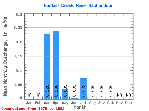
| Statistic | Jan | Feb | Mar | Apr | May | Jun | Jul | Aug | Sep | Oct | Nov | Dec | Annual |
|---|---|---|---|---|---|---|---|---|---|---|---|---|---|
| Mean | 0.23 | 0.24 | 0.04 | 0.00 | 0.07 | 0.00 | 0.00 | 0.00 | |||||
| Standard Deviation | 0.31 | 0.41 | 0.05 | 0.00 | 0.15 | 0.00 | 0.00 | 0.00 | |||||
| Min | 0.00 | 0.00 | 0.00 | 0.00 | 0.00 | 0.00 | 0.00 | 0.00 | |||||
| Max | 0.94 | 1.46 | 0.18 | 0.01 | 0.43 | 0.00 | 0.00 | 0.00 | |||||
| Coefficient of Variation | 1.36 | 1.73 | 1.51 | 1.45 | 2.05 | 3.74 |
 Return to R-Arctic Net Home Page