|
|
|||||||||||||||||
| Point ID: 5372 | Downloads | Plots | Site Data | Code: 05JF011 |
|
|
|||||||||||||||||
| Download | |
|---|---|
| Site Descriptor Information | Site Time Series Data |
| Link to all available data | |
| View: | Time Series | All |
| Units: | mm |
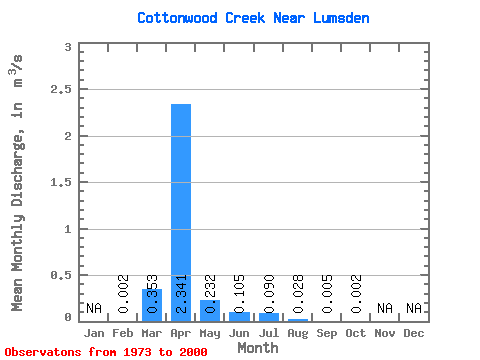
| Statistic | Jan | Feb | Mar | Apr | May | Jun | Jul | Aug | Sep | Oct | Nov | Dec | Annual |
|---|---|---|---|---|---|---|---|---|---|---|---|---|---|
| Mean | 0.00 | 0.35 | 2.34 | 0.23 | 0.10 | 0.09 | 0.03 | 0.01 | 0.00 | ||||
| Standard Deviation | 0.00 | 0.76 | 3.84 | 0.55 | 0.33 | 0.29 | 0.14 | 0.03 | 0.01 | ||||
| Min | 0.00 | 0.00 | 0.00 | 0.00 | 0.00 | 0.00 | 0.00 | 0.00 | 0.00 | ||||
| Max | 0.00 | 3.50 | 12.20 | 2.70 | 1.46 | 1.21 | 0.73 | 0.14 | 0.05 | ||||
| Coefficient of Variation | 0.86 | 2.14 | 1.64 | 2.35 | 3.11 | 3.20 | 4.97 | 5.11 | 5.08 |
 Return to R-Arctic Net Home Page