|
|
|||||||||||||||||
| Point ID: 5359 | Downloads | Plots | Site Data | Code: 05JE004 |
|
|
|||||||||||||||||
| Download | |
|---|---|
| Site Descriptor Information | Site Time Series Data |
| Link to all available data | |
| View: | Time Series | All |
| Units: | mm |
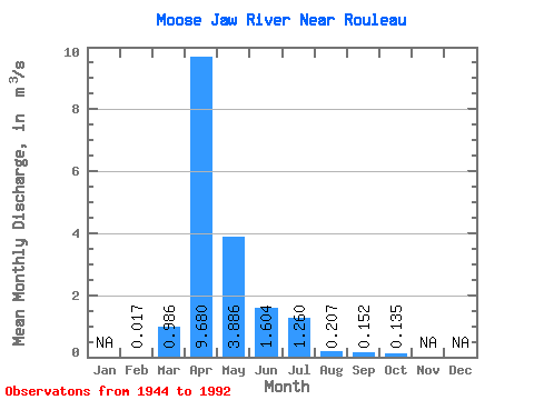
| Statistic | Jan | Feb | Mar | Apr | May | Jun | Jul | Aug | Sep | Oct | Nov | Dec | Annual |
|---|---|---|---|---|---|---|---|---|---|---|---|---|---|
| Mean | 0.02 | 0.99 | 9.68 | 3.89 | 1.60 | 1.26 | 0.21 | 0.15 | 0.14 | ||||
| Standard Deviation | 0.02 | 2.03 | 13.04 | 7.30 | 5.86 | 2.58 | 0.57 | 0.82 | 0.47 | ||||
| Min | 0.00 | 0.00 | 0.00 | 0.00 | 0.00 | 0.00 | 0.00 | 0.00 | 0.00 | ||||
| Max | 0.03 | 8.23 | 49.30 | 27.80 | 40.70 | 11.20 | 3.07 | 5.21 | 2.67 | ||||
| Coefficient of Variation | 1.25 | 2.06 | 1.35 | 1.88 | 3.66 | 2.05 | 2.77 | 5.43 | 3.51 |
 Return to R-Arctic Net Home Page