|
|
|||||||||||||||||
| Point ID: 5356 | Downloads | Plots | Site Data | Code: 05JE001 |
|
|
|||||||||||||||||
| Download | |
|---|---|
| Site Descriptor Information | Site Time Series Data |
| Link to all available data | |
| View: | Time Series | All |
| Units: | mm |
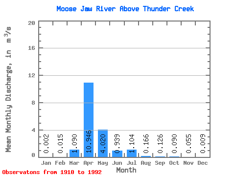
| Statistic | Jan | Feb | Mar | Apr | May | Jun | Jul | Aug | Sep | Oct | Nov | Dec | Annual |
|---|---|---|---|---|---|---|---|---|---|---|---|---|---|
| Mean | 0.00 | 0.01 | 1.09 | 10.95 | 4.02 | 0.94 | 1.10 | 0.17 | 0.13 | 0.09 | 0.06 | 0.01 | 1.25 |
| Standard Deviation | 0.00 | 0.03 | 2.06 | 16.29 | 8.61 | 1.66 | 3.06 | 0.42 | 0.80 | 0.41 | 0.09 | 0.02 | 1.33 |
| Min | 0.00 | 0.00 | 0.00 | 0.00 | 0.00 | 0.00 | 0.00 | 0.00 | 0.00 | 0.00 | 0.00 | 0.00 | 0.01 |
| Max | 0.01 | 0.10 | 12.60 | 67.10 | 38.70 | 9.52 | 19.20 | 2.56 | 6.54 | 3.34 | 0.30 | 0.06 | 4.04 |
| Coefficient of Variation | 1.94 | 1.92 | 1.89 | 1.49 | 2.14 | 1.77 | 2.77 | 2.51 | 6.36 | 4.59 | 1.57 | 1.80 | 1.06 |
 Return to R-Arctic Net Home Page