|
|
|||||||||||||||||
| Point ID: 5350 | Downloads | Plots | Site Data | Code: 05JC004 |
|
|
|||||||||||||||||
| Download | |
|---|---|
| Site Descriptor Information | Site Time Series Data |
| Link to all available data | |
| View: | Time Series | All |
| Units: | mm |
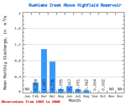
| Statistic | Jan | Feb | Mar | Apr | May | Jun | Jul | Aug | Sep | Oct | Nov | Dec | Annual |
|---|---|---|---|---|---|---|---|---|---|---|---|---|---|
| Mean | 0.26 | 1.09 | 0.78 | 0.10 | 0.17 | 0.09 | 0.06 | 0.00 | 0.00 | ||||
| Standard Deviation | 0.50 | 1.48 | 1.19 | 0.13 | 0.50 | 0.35 | 0.33 | 0.02 | 0.01 | ||||
| Min | 0.00 | 0.00 | 0.00 | 0.00 | 0.00 | 0.00 | 0.00 | 0.00 | 0.00 | ||||
| Max | 1.41 | 6.27 | 4.54 | 0.55 | 2.46 | 1.97 | 1.94 | 0.11 | 0.04 | ||||
| Coefficient of Variation | 1.95 | 1.36 | 1.53 | 1.34 | 2.97 | 3.84 | 5.31 | 4.52 | 3.29 |
 Return to R-Arctic Net Home Page