|
|
|||||||||||||||||
| Point ID: 5346 | Downloads | Plots | Site Data | Code: 05JB004 |
|
|
|||||||||||||||||
| Download | |
|---|---|
| Site Descriptor Information | Site Time Series Data |
| Link to all available data | |
| View: | Time Series | All |
| Units: | mm |
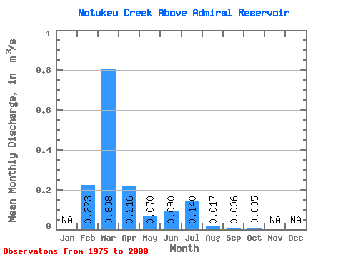
| Statistic | Jan | Feb | Mar | Apr | May | Jun | Jul | Aug | Sep | Oct | Nov | Dec | Annual |
|---|---|---|---|---|---|---|---|---|---|---|---|---|---|
| Mean | 0.22 | 0.81 | 0.22 | 0.07 | 0.09 | 0.14 | 0.02 | 0.01 | 0.01 | ||||
| Standard Deviation | 0.39 | 1.06 | 0.34 | 0.17 | 0.20 | 0.39 | 0.06 | 0.01 | 0.01 | ||||
| Min | 0.00 | 0.01 | 0.00 | 0.00 | 0.00 | 0.00 | 0.00 | 0.00 | 0.00 | ||||
| Max | 1.21 | 4.38 | 1.45 | 0.85 | 0.89 | 1.67 | 0.28 | 0.04 | 0.05 | ||||
| Coefficient of Variation | 1.74 | 1.31 | 1.59 | 2.39 | 2.20 | 2.76 | 3.34 | 2.17 | 2.26 |
 Return to R-Arctic Net Home Page