|
|
|||||||||||||||||
| Point ID: 5336 | Downloads | Plots | Site Data | Code: 05HH001 |
|
|
|||||||||||||||||
| Download | |
|---|---|
| Site Descriptor Information | Site Time Series Data |
| Link to all available data | |
| View: | Time Series | All |
| Units: | mm |
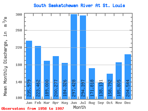
| Statistic | Jan | Feb | Mar | Apr | May | Jun | Jul | Aug | Sep | Oct | Nov | Dec | Annual |
|---|---|---|---|---|---|---|---|---|---|---|---|---|---|
| Mean | 235.98 | 223.46 | 189.00 | 200.28 | 184.33 | 297.43 | 294.40 | 171.82 | 138.13 | 158.79 | 185.81 | 204.54 | 206.07 |
| Standard Deviation | 103.80 | 103.22 | 83.20 | 116.19 | 124.19 | 234.07 | 250.25 | 118.89 | 79.32 | 82.89 | 77.47 | 87.84 | 66.72 |
| Min | 40.10 | 40.10 | 54.70 | 62.70 | 34.80 | 37.80 | 39.90 | 50.80 | 30.40 | 31.40 | 27.80 | 31.10 | 79.81 |
| Max | 362.00 | 387.00 | 353.00 | 555.00 | 463.00 | 822.00 | 1070.00 | 549.00 | 406.00 | 351.00 | 338.00 | 335.00 | 338.62 |
| Coefficient of Variation | 0.44 | 0.46 | 0.44 | 0.58 | 0.67 | 0.79 | 0.85 | 0.69 | 0.57 | 0.52 | 0.42 | 0.43 | 0.32 |
 Return to R-Arctic Net Home Page