|
|
|||||||||||||||||
| Point ID: 5329 | Downloads | Plots | Site Data | Code: 05HG011 |
|
|
|||||||||||||||||
| Download | |
|---|---|
| Site Descriptor Information | Site Time Series Data |
| Link to all available data | |
| View: | Time Series | All |
| Units: | mm |
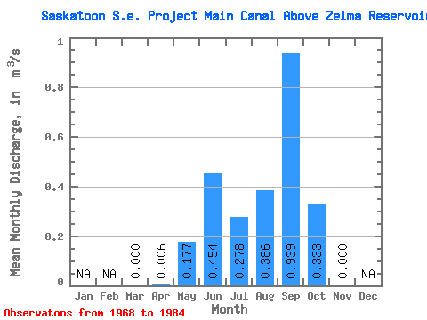
| Statistic | Jan | Feb | Mar | Apr | May | Jun | Jul | Aug | Sep | Oct | Nov | Dec | Annual |
|---|---|---|---|---|---|---|---|---|---|---|---|---|---|
| Mean | 0.00 | 0.01 | 0.18 | 0.45 | 0.28 | 0.39 | 0.94 | 0.33 | 0.00 | ||||
| Standard Deviation | 0.00 | 0.02 | 0.24 | 0.59 | 0.45 | 0.42 | 0.59 | 0.29 | 0.00 | ||||
| Min | 0.00 | 0.00 | 0.00 | 0.00 | 0.00 | 0.00 | 0.00 | 0.00 | 0.00 | ||||
| Max | 0.00 | 0.07 | 0.79 | 1.64 | 1.69 | 1.36 | 2.05 | 1.04 | 0.00 | ||||
| Coefficient of Variation | 3.46 | 1.36 | 1.31 | 1.62 | 1.09 | 0.63 | 0.87 |
 Return to R-Arctic Net Home Page