|
|
|||||||||||||||||
| Point ID: 5325 | Downloads | Plots | Site Data | Code: 05HG007 |
|
|
|||||||||||||||||
| Download | |
|---|---|
| Site Descriptor Information | Site Time Series Data |
| Link to all available data | |
| View: | Time Series | All |
| Units: | mm |
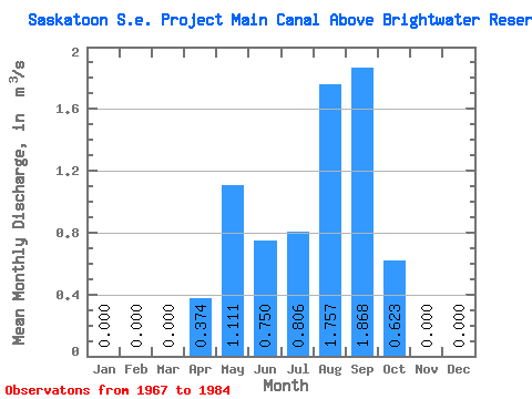
| Statistic | Jan | Feb | Mar | Apr | May | Jun | Jul | Aug | Sep | Oct | Nov | Dec | Annual |
|---|---|---|---|---|---|---|---|---|---|---|---|---|---|
| Mean | 0.00 | 0.00 | 0.00 | 0.37 | 1.11 | 0.75 | 0.81 | 1.76 | 1.87 | 0.62 | 0.00 | 0.00 | 0.00 |
| Standard Deviation | 0.00 | 0.76 | 1.19 | 0.86 | 0.84 | 1.61 | 1.95 | 1.78 | 0.00 | ||||
| Min | 0.00 | 0.00 | 0.00 | 0.00 | 0.00 | 0.00 | 0.00 | 0.00 | 0.00 | 0.00 | 0.00 | 0.00 | 0.00 |
| Max | 0.00 | 0.00 | 0.00 | 2.31 | 3.38 | 2.43 | 3.16 | 6.87 | 7.38 | 7.42 | 0.00 | 0.00 | 0.00 |
| Coefficient of Variation | 2.04 | 1.07 | 1.15 | 1.04 | 0.92 | 1.04 | 2.85 |
 Return to R-Arctic Net Home Page