|
|
|||||||||||||||||
| Point ID: 5323 | Downloads | Plots | Site Data | Code: 05HG004 |
|
|
|||||||||||||||||
| Download | |
|---|---|
| Site Descriptor Information | Site Time Series Data |
| Link to all available data | |
| View: | Time Series | All |
| Units: | mm |
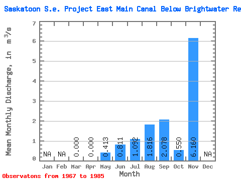
| Statistic | Jan | Feb | Mar | Apr | May | Jun | Jul | Aug | Sep | Oct | Nov | Dec | Annual |
|---|---|---|---|---|---|---|---|---|---|---|---|---|---|
| Mean | 0.00 | 0.00 | 0.41 | 0.81 | 1.09 | 1.82 | 2.08 | 0.55 | 6.16 | ||||
| Standard Deviation | 0.00 | 0.00 | 0.48 | 0.74 | 1.29 | 1.38 | 1.57 | 1.62 | |||||
| Min | 0.00 | 0.00 | 0.00 | 0.00 | 0.00 | 0.00 | 0.00 | 0.00 | 6.16 | ||||
| Max | 0.00 | 0.00 | 1.49 | 2.12 | 4.96 | 6.39 | 6.70 | 6.98 | 6.16 | ||||
| Coefficient of Variation | 1.17 | 0.92 | 1.19 | 0.76 | 0.75 | 2.95 |
 Return to R-Arctic Net Home Page