|
|
|||||||||||||||||
| Point ID: 5322 | Downloads | Plots | Site Data | Code: 05HG002 |
|
|
|||||||||||||||||
| Download | |
|---|---|
| Site Descriptor Information | Site Time Series Data |
| Link to all available data | |
| View: | Time Series | All |
| Units: | mm |
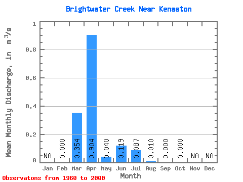
| Statistic | Jan | Feb | Mar | Apr | May | Jun | Jul | Aug | Sep | Oct | Nov | Dec | Annual |
|---|---|---|---|---|---|---|---|---|---|---|---|---|---|
| Mean | 0.00 | 0.35 | 0.90 | 0.04 | 0.12 | 0.09 | 0.01 | 0.00 | 0.00 | ||||
| Standard Deviation | 0.00 | 0.71 | 1.61 | 0.07 | 0.65 | 0.31 | 0.05 | 0.00 | 0.00 | ||||
| Min | 0.00 | 0.00 | 0.00 | 0.00 | 0.00 | 0.00 | 0.00 | 0.00 | 0.00 | ||||
| Max | 0.00 | 3.49 | 7.82 | 0.31 | 4.15 | 1.55 | 0.34 | 0.00 | 0.00 | ||||
| Coefficient of Variation | 2.00 | 1.78 | 1.77 | 5.43 | 3.60 | 5.24 | 6.40 | 6.40 |
 Return to R-Arctic Net Home Page