|
|
|||||||||||||||||
| Point ID: 5321 | Downloads | Plots | Site Data | Code: 05HG001 |
|
|
|||||||||||||||||
| Download | |
|---|---|
| Site Descriptor Information | Site Time Series Data |
| Link to all available data | |
| View: | Time Series | All |
| Units: | mm |
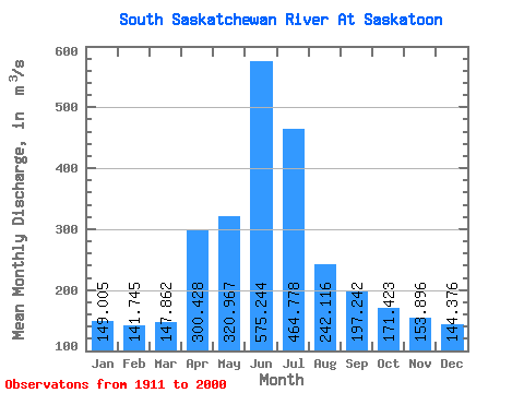
| Statistic | Jan | Feb | Mar | Apr | May | Jun | Jul | Aug | Sep | Oct | Nov | Dec | Annual |
|---|---|---|---|---|---|---|---|---|---|---|---|---|---|
| Mean | 149.00 | 141.75 | 147.86 | 300.43 | 320.97 | 575.24 | 464.78 | 242.12 | 197.24 | 171.42 | 153.90 | 144.38 | 255.09 |
| Standard Deviation | 120.71 | 111.08 | 90.45 | 202.07 | 238.73 | 418.27 | 342.20 | 167.95 | 158.73 | 102.42 | 76.61 | 94.19 | 98.59 |
| Min | 28.70 | 31.30 | 40.90 | 49.30 | 36.20 | 39.00 | 42.00 | 49.20 | 36.30 | 37.30 | 31.60 | 28.30 | 84.62 |
| Max | 378.00 | 388.00 | 434.00 | 1260.00 | 1530.00 | 1920.00 | 1710.00 | 954.00 | 842.00 | 494.00 | 351.00 | 346.00 | 579.71 |
| Coefficient of Variation | 0.81 | 0.78 | 0.61 | 0.67 | 0.74 | 0.73 | 0.74 | 0.69 | 0.81 | 0.60 | 0.50 | 0.65 | 0.39 |
 Return to R-Arctic Net Home Page