|
|
|||||||||||||||||
| Point ID: 5307 | Downloads | Plots | Site Data | Code: 05HF001 |
|
|
|||||||||||||||||
| Download | |
|---|---|
| Site Descriptor Information | Site Time Series Data |
| Link to all available data | |
| View: | Time Series | All |
| Units: | mm |
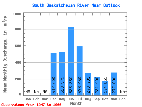
| Statistic | Jan | Feb | Mar | Apr | May | Jun | Jul | Aug | Sep | Oct | Nov | Dec | Annual |
|---|---|---|---|---|---|---|---|---|---|---|---|---|---|
| Mean | 512.00 | 528.58 | 825.35 | 593.45 | 270.80 | 221.40 | 174.87 | 277.00 | |||||
| Standard Deviation | 339.06 | 305.32 | 366.06 | 266.39 | 121.46 | 194.17 | 115.24 | ||||||
| Min | 200.00 | 167.00 | 397.00 | 181.00 | 52.90 | 32.00 | 31.20 | 277.00 | |||||
| Max | 1210.00 | 1550.00 | 1790.00 | 1170.00 | 523.00 | 763.00 | 483.00 | 277.00 | |||||
| Coefficient of Variation | 0.66 | 0.58 | 0.44 | 0.45 | 0.45 | 0.88 | 0.66 |
 Return to R-Arctic Net Home Page