|
|
|||||||||||||||||
| Point ID: 5298 | Downloads | Plots | Site Data | Code: 05HD030 |
|
|
|||||||||||||||||
| Download | |
|---|---|
| Site Descriptor Information | Site Time Series Data |
| Link to all available data | |
| View: | Time Series | All |
| Units: | mm |
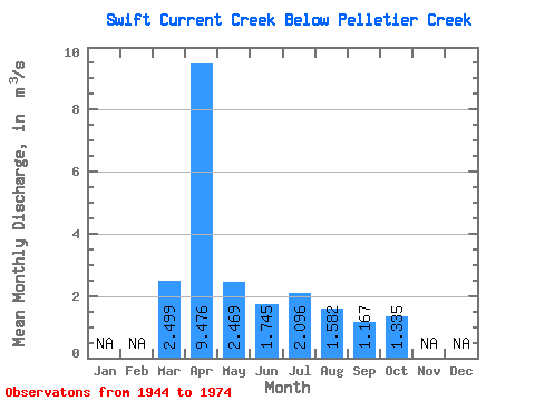
| Statistic | Jan | Feb | Mar | Apr | May | Jun | Jul | Aug | Sep | Oct | Nov | Dec | Annual |
|---|---|---|---|---|---|---|---|---|---|---|---|---|---|
| Mean | 2.50 | 9.48 | 2.47 | 1.75 | 2.10 | 1.58 | 1.17 | 1.33 | |||||
| Standard Deviation | 2.75 | 12.43 | 2.53 | 0.94 | 1.26 | 0.70 | 0.67 | 1.29 | |||||
| Min | 0.35 | 0.89 | 0.54 | 0.77 | 0.60 | 0.63 | 0.24 | 0.10 | |||||
| Max | 11.80 | 55.60 | 10.30 | 5.35 | 7.71 | 3.07 | 2.56 | 6.78 | |||||
| Coefficient of Variation | 1.10 | 1.31 | 1.02 | 0.54 | 0.60 | 0.45 | 0.57 | 0.96 |
 Return to R-Arctic Net Home Page