|
|
|||||||||||||||||
| Point ID: 5272 | Downloads | Plots | Site Data | Code: 05HA069 |
|
|
|||||||||||||||||
| Download | |
|---|---|
| Site Descriptor Information | Site Time Series Data |
| Link to all available data | |
| View: | Time Series | All |
| Units: | mm |
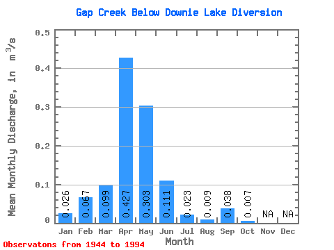
| Statistic | Jan | Feb | Mar | Apr | May | Jun | Jul | Aug | Sep | Oct | Nov | Dec | Annual |
|---|---|---|---|---|---|---|---|---|---|---|---|---|---|
| Mean | 0.03 | 0.07 | 0.10 | 0.43 | 0.30 | 0.11 | 0.02 | 0.01 | 0.04 | 0.01 | |||
| Standard Deviation | 0.01 | 0.10 | 0.25 | 1.28 | 0.71 | 0.27 | 0.07 | 0.05 | 0.17 | 0.03 | |||
| Min | 0.02 | 0.00 | 0.00 | 0.00 | 0.00 | 0.00 | 0.00 | 0.00 | 0.00 | 0.00 | |||
| Max | 0.04 | 0.25 | 1.46 | 6.99 | 4.03 | 1.67 | 0.41 | 0.34 | 1.07 | 0.14 | |||
| Coefficient of Variation | 0.53 | 1.56 | 2.49 | 3.00 | 2.35 | 2.42 | 2.92 | 5.62 | 4.40 | 3.89 |
 Return to R-Arctic Net Home Page