|
|
|||||||||||||||||
| Point ID: 5237 | Downloads | Plots | Site Data | Code: 05HA012 |
|
|
|||||||||||||||||
| Download | |
|---|---|
| Site Descriptor Information | Site Time Series Data |
| Link to all available data | |
| View: | Time Series | All |
| Units: | mm |
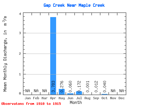
| Statistic | Jan | Feb | Mar | Apr | May | Jun | Jul | Aug | Sep | Oct | Nov | Dec | Annual |
|---|---|---|---|---|---|---|---|---|---|---|---|---|---|
| Mean | 3.78 | 0.28 | 0.06 | 0.17 | 0.00 | 0.01 | 0.04 | ||||||
| Standard Deviation | 3.10 | 0.17 | 0.08 | 0.38 | 0.00 | 0.02 | 0.07 | ||||||
| Min | 1.51 | 0.12 | 0.00 | 0.00 | 0.00 | 0.00 | 0.00 | ||||||
| Max | 8.35 | 0.44 | 0.15 | 0.85 | 0.00 | 0.04 | 0.12 | ||||||
| Coefficient of Variation | 0.82 | 0.61 | 1.32 | 2.21 | 2.00 | 1.73 | 1.73 |
 Return to R-Arctic Net Home Page