|
|
|||||||||||||||||
| Point ID: 5226 | Downloads | Plots | Site Data | Code: 05GG010 |
|
|
|||||||||||||||||
| Download | |
|---|---|
| Site Descriptor Information | Site Time Series Data |
| Link to all available data | |
| View: | Time Series | All |
| Units: | mm |
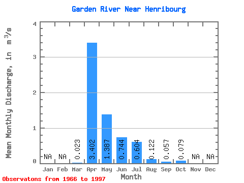
| Statistic | Jan | Feb | Mar | Apr | May | Jun | Jul | Aug | Sep | Oct | Nov | Dec | Annual |
|---|---|---|---|---|---|---|---|---|---|---|---|---|---|
| Mean | 0.02 | 3.40 | 1.39 | 0.74 | 0.60 | 0.12 | 0.06 | 0.08 | |||||
| Standard Deviation | 0.08 | 3.83 | 1.89 | 1.54 | 1.49 | 0.33 | 0.16 | 0.14 | |||||
| Min | 0.00 | 0.00 | 0.00 | 0.00 | 0.00 | 0.00 | 0.00 | 0.00 | |||||
| Max | 0.43 | 15.50 | 7.43 | 7.05 | 6.45 | 1.74 | 0.73 | 0.56 | |||||
| Coefficient of Variation | 3.36 | 1.12 | 1.36 | 2.08 | 2.47 | 2.69 | 2.78 | 1.77 |
 Return to R-Arctic Net Home Page