|
|
|||||||||||||||||
| Point ID: 5221 | Downloads | Plots | Site Data | Code: 05GG001 |
|
|
|||||||||||||||||
| Download | |
|---|---|
| Site Descriptor Information | Site Time Series Data |
| Link to all available data | |
| View: | Time Series | All |
| Units: | mm |
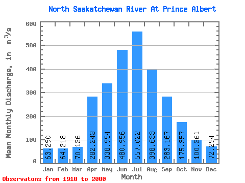
| Statistic | Jan | Feb | Mar | Apr | May | Jun | Jul | Aug | Sep | Oct | Nov | Dec | Annual |
|---|---|---|---|---|---|---|---|---|---|---|---|---|---|
| Mean | 63.29 | 64.22 | 70.13 | 282.24 | 338.95 | 480.96 | 557.02 | 398.63 | 283.17 | 175.36 | 100.36 | 72.29 | 239.84 |
| Standard Deviation | 35.57 | 38.11 | 43.53 | 135.01 | 208.16 | 200.43 | 244.81 | 147.13 | 136.60 | 56.68 | 35.98 | 37.05 | 58.53 |
| Min | 19.50 | 19.10 | 23.60 | 69.90 | 82.90 | 186.00 | 194.00 | 139.00 | 137.00 | 93.10 | 45.30 | 20.90 | 135.88 |
| Max | 143.00 | 142.00 | 202.00 | 765.00 | 1510.00 | 1110.00 | 1710.00 | 851.00 | 1110.00 | 353.00 | 187.00 | 180.00 | 409.62 |
| Coefficient of Variation | 0.56 | 0.59 | 0.62 | 0.48 | 0.61 | 0.42 | 0.44 | 0.37 | 0.48 | 0.32 | 0.36 | 0.51 | 0.24 |
 Return to R-Arctic Net Home Page