|
|
|||||||||||||||||
| Point ID: 5217 | Downloads | Plots | Site Data | Code: 05GD002 |
|
|
|||||||||||||||||
| Download | |
|---|---|
| Site Descriptor Information | Site Time Series Data |
| Link to all available data | |
| View: | Time Series | All |
| Units: | mm |
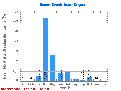
| Statistic | Jan | Feb | Mar | Apr | May | Jun | Jul | Aug | Sep | Oct | Nov | Dec | Annual |
|---|---|---|---|---|---|---|---|---|---|---|---|---|---|
| Mean | 0.05 | 0.63 | 0.26 | 0.08 | 0.11 | 0.03 | 0.01 | 0.04 | |||||
| Standard Deviation | 0.05 | 0.76 | 0.41 | 0.12 | 0.18 | 0.05 | 0.01 | 0.06 | |||||
| Min | 0.00 | 0.07 | 0.01 | 0.00 | 0.00 | 0.00 | 0.00 | 0.00 | |||||
| Max | 0.16 | 2.96 | 1.65 | 0.53 | 0.64 | 0.19 | 0.06 | 0.24 | |||||
| Coefficient of Variation | 1.08 | 1.20 | 1.56 | 1.40 | 1.69 | 1.81 | 1.25 | 1.34 |
 Return to R-Arctic Net Home Page