|
|
|||||||||||||||||
| Point ID: 5207 | Downloads | Plots | Site Data | Code: 05GA007 |
|
|
|||||||||||||||||
| Download | |
|---|---|
| Site Descriptor Information | Site Time Series Data |
| Link to all available data | |
| View: | Time Series | All |
| Units: | mm |
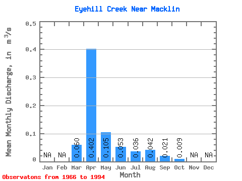
| Statistic | Jan | Feb | Mar | Apr | May | Jun | Jul | Aug | Sep | Oct | Nov | Dec | Annual |
|---|---|---|---|---|---|---|---|---|---|---|---|---|---|
| Mean | 0.06 | 0.40 | 0.10 | 0.05 | 0.04 | 0.04 | 0.02 | 0.01 | |||||
| Standard Deviation | 0.13 | 0.61 | 0.17 | 0.07 | 0.09 | 0.11 | 0.05 | 0.03 | |||||
| Min | 0.00 | 0.00 | 0.00 | 0.00 | 0.00 | 0.00 | 0.00 | 0.00 | |||||
| Max | 0.54 | 2.38 | 0.73 | 0.29 | 0.42 | 0.45 | 0.20 | 0.13 | |||||
| Coefficient of Variation | 2.15 | 1.52 | 1.59 | 1.37 | 2.50 | 2.65 | 2.31 | 2.69 |
 Return to R-Arctic Net Home Page