|
|
|||||||||||||||||
| Point ID: 5186 | Downloads | Plots | Site Data | Code: 04NA001 |
|
|
|||||||||||||||||
| Download | |
|---|---|
| Site Descriptor Information | Site Time Series Data |
| Link to all available data | |
| View: | Time Series | All |
| Units: | mm |
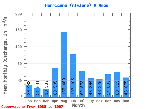
| Statistic | Jan | Feb | Mar | Apr | May | Jun | Jul | Aug | Sep | Oct | Nov | Dec | Annual |
|---|---|---|---|---|---|---|---|---|---|---|---|---|---|
| Mean | 29.48 | 21.63 | 19.59 | 69.50 | 155.48 | 102.41 | 62.87 | 45.29 | 43.33 | 54.70 | 60.31 | 46.88 | 59.16 |
| Standard Deviation | 7.99 | 5.12 | 6.08 | 34.36 | 36.35 | 32.32 | 21.60 | 18.99 | 22.15 | 23.11 | 23.38 | 17.46 | 10.38 |
| Min | 13.30 | 11.40 | 9.77 | 14.10 | 80.50 | 54.90 | 27.60 | 11.20 | 14.30 | 21.20 | 17.70 | 17.30 | 38.08 |
| Max | 57.90 | 41.20 | 42.70 | 164.00 | 278.00 | 240.00 | 143.00 | 103.00 | 117.00 | 118.00 | 121.00 | 117.00 | 87.14 |
| Coefficient of Variation | 0.27 | 0.24 | 0.31 | 0.49 | 0.23 | 0.32 | 0.34 | 0.42 | 0.51 | 0.42 | 0.39 | 0.37 | 0.17 |
 Return to R-Arctic Net Home Page