|
|
|||||||||||||||||
| Point ID: 5176 | Downloads | Plots | Site Data | Code: 03LD004 |
|
|
|||||||||||||||||
| Download | |
|---|---|
| Site Descriptor Information | Site Time Series Data |
| Link to all available data | |
| View: | Time Series | All |
| Units: | mm |
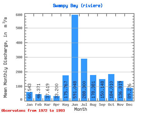
| Statistic | Jan | Feb | Mar | Apr | May | Jun | Jul | Aug | Sep | Oct | Nov | Dec | Annual |
|---|---|---|---|---|---|---|---|---|---|---|---|---|---|
| Mean | 60.54 | 46.37 | 37.62 | 33.20 | 175.77 | 591.05 | 288.30 | 178.38 | 150.15 | 184.01 | 136.82 | 89.28 | 165.07 |
| Standard Deviation | 11.10 | 8.85 | 7.26 | 6.49 | 147.64 | 176.44 | 105.29 | 68.67 | 58.37 | 80.05 | 32.78 | 16.15 | 24.06 |
| Min | 44.80 | 31.00 | 24.70 | 21.70 | 31.30 | 391.00 | 140.00 | 80.40 | 63.10 | 77.80 | 92.60 | 68.50 | 107.71 |
| Max | 94.70 | 68.80 | 53.00 | 49.30 | 521.00 | 986.00 | 592.00 | 352.00 | 313.00 | 370.00 | 203.00 | 139.00 | 210.03 |
| Coefficient of Variation | 0.18 | 0.19 | 0.19 | 0.20 | 0.84 | 0.30 | 0.36 | 0.39 | 0.39 | 0.43 | 0.24 | 0.18 | 0.15 |
 Return to R-Arctic Net Home Page