|
|
|||||||||||||||||
| Point ID: 5172 | Downloads | Plots | Site Data | Other Close Sites | Code: 03KC004 |
|
|
|||||||||||||||||
| Download | |
|---|---|
| Site Descriptor Information | Site Time Series Data |
| Link to all available data | |
| View: | Time Series | All |
| Units: | mm |
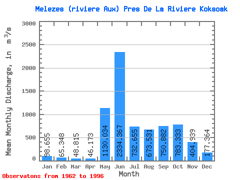
| Statistic | Jan | Feb | Mar | Apr | May | Jun | Jul | Aug | Sep | Oct | Nov | Dec | Annual |
|---|---|---|---|---|---|---|---|---|---|---|---|---|---|
| Mean | 98.66 | 65.35 | 48.81 | 46.17 | 1130.03 | 2334.37 | 732.65 | 673.53 | 750.88 | 783.33 | 404.94 | 177.36 | 611.41 |
| Standard Deviation | 27.29 | 20.32 | 17.13 | 17.34 | 723.67 | 922.28 | 260.54 | 413.29 | 252.32 | 218.86 | 151.03 | 48.83 | 86.78 |
| Min | 60.10 | 33.70 | 25.00 | 23.20 | 44.10 | 645.00 | 246.00 | 219.00 | 330.00 | 305.00 | 199.00 | 112.00 | 338.08 |
| Max | 170.00 | 122.00 | 103.00 | 100.00 | 2400.00 | 4170.00 | 1190.00 | 2190.00 | 1510.00 | 1120.00 | 858.00 | 298.00 | 752.87 |
| Coefficient of Variation | 0.28 | 0.31 | 0.35 | 0.38 | 0.64 | 0.40 | 0.36 | 0.61 | 0.34 | 0.28 | 0.37 | 0.28 | 0.14 |
| Other Close Sites | ||||||
|---|---|---|---|---|---|---|
| PointID | Latitude | Longitude | Drainage Area | Source | Name | |
| 5171 | "MELEZES (RIVIERE AUX) PRES DE LA RIVIERE KOKSOAK-2" | 57.68 | -1236787 | Hydat | ||
 Return to R-Arctic Net Home Page