|
|
|||||||||||||||||
| Point ID: 5168 | Downloads | Plots | Site Data | Code: 03JB001 |
|
|
|||||||||||||||||
| Download | |
|---|---|
| Site Descriptor Information | Site Time Series Data |
| Link to all available data | |
| View: | Time Series | All |
| Units: | mm |
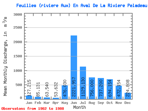
| Statistic | Jan | Feb | Mar | Apr | May | Jun | Jul | Aug | Sep | Oct | Nov | Dec | Annual |
|---|---|---|---|---|---|---|---|---|---|---|---|---|---|
| Mean | 127.22 | 85.13 | 63.54 | 53.63 | 476.03 | 2221.96 | 1129.13 | 756.00 | 737.20 | 694.15 | 472.15 | 224.81 | 589.96 |
| Standard Deviation | 43.08 | 28.08 | 21.54 | 21.64 | 424.66 | 601.70 | 325.44 | 251.21 | 266.52 | 192.91 | 151.26 | 71.78 | 73.50 |
| Min | 69.60 | 42.40 | 25.60 | 16.90 | 25.30 | 995.00 | 697.00 | 396.00 | 358.00 | 425.00 | 214.00 | 119.00 | 454.33 |
| Max | 222.00 | 137.00 | 102.00 | 92.40 | 1510.00 | 3090.00 | 1770.00 | 1490.00 | 1430.00 | 1180.00 | 725.00 | 391.00 | 716.07 |
| Coefficient of Variation | 0.34 | 0.33 | 0.34 | 0.40 | 0.89 | 0.27 | 0.29 | 0.33 | 0.36 | 0.28 | 0.32 | 0.32 | 0.12 |
 Return to R-Arctic Net Home Page