|
|
|||||||||||||||||
| Point ID: 5165 | Downloads | Plots | Site Data | Other Close Sites | Code: 03HB004 |
|
|
|||||||||||||||||
| Download | |
|---|---|
| Site Descriptor Information | Site Time Series Data |
| Link to all available data | |
| View: | Time Series | All |
| Units: | mm |
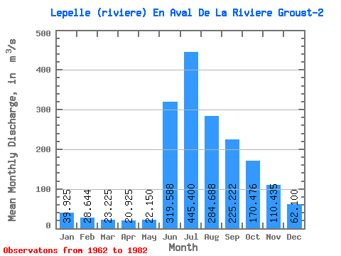
| Statistic | Jan | Feb | Mar | Apr | May | Jun | Jul | Aug | Sep | Oct | Nov | Dec | Annual |
|---|---|---|---|---|---|---|---|---|---|---|---|---|---|
| Mean | 39.92 | 28.64 | 23.23 | 20.93 | 22.15 | 319.59 | 445.40 | 284.69 | 225.22 | 170.48 | 110.44 | 62.10 | 146.22 |
| Standard Deviation | 11.08 | 8.42 | 7.38 | 6.93 | 8.60 | 148.66 | 132.88 | 85.94 | 71.16 | 51.01 | 39.97 | 19.08 | 37.99 |
| Min | 25.80 | 18.50 | 13.30 | 11.20 | 10.30 | 98.40 | 269.00 | 184.00 | 144.00 | 94.10 | 72.00 | 38.70 | 104.80 |
| Max | 65.40 | 53.00 | 45.00 | 41.30 | 48.30 | 599.00 | 664.00 | 539.00 | 426.00 | 279.00 | 212.00 | 98.40 | 252.17 |
| Coefficient of Variation | 0.28 | 0.29 | 0.32 | 0.33 | 0.39 | 0.47 | 0.30 | 0.30 | 0.32 | 0.30 | 0.36 | 0.31 | 0.26 |
| Other Close Sites | ||||||
|---|---|---|---|---|---|---|
| PointID | Latitude | Longitude | Drainage Area | Source | Name | |
| 5166 | "LEPELLE (RIVIERE) EN AVAL DE LA RIVIERE GROUST-1" | 60.19 | -976308 | Hydat | ||
 Return to R-Arctic Net Home Page