|
|
|||||||||||||||||
| Point ID: 5161 | Downloads | Plots | Site Data | Code: 03HA009 |
|
|
|||||||||||||||||
| Download | |
|---|---|
| Site Descriptor Information | Site Time Series Data |
| Link to all available data | |
| View: | Time Series | All |
| Units: | mm |
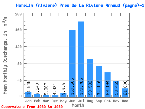
| Statistic | Jan | Feb | Mar | Apr | May | Jun | Jul | Aug | Sep | Oct | Nov | Dec | Annual |
|---|---|---|---|---|---|---|---|---|---|---|---|---|---|
| Mean | 11.85 | 7.54 | 5.39 | 4.42 | 9.98 | 159.51 | 179.76 | 90.53 | 74.12 | 59.19 | 38.47 | 21.01 | 54.15 |
| Standard Deviation | 5.17 | 3.77 | 3.07 | 2.79 | 9.72 | 71.97 | 39.82 | 20.66 | 19.00 | 13.16 | 8.00 | 6.23 | 7.94 |
| Min | 1.91 | 0.72 | 0.47 | 0.36 | 0.99 | 46.30 | 126.00 | 57.40 | 45.70 | 34.90 | 27.70 | 11.10 | 38.66 |
| Max | 20.30 | 15.90 | 13.70 | 13.00 | 34.30 | 263.00 | 269.00 | 127.00 | 125.00 | 85.20 | 52.80 | 31.50 | 68.67 |
| Coefficient of Variation | 0.44 | 0.50 | 0.57 | 0.63 | 0.97 | 0.45 | 0.22 | 0.23 | 0.26 | 0.22 | 0.21 | 0.30 | 0.15 |
 Return to R-Arctic Net Home Page