|
|
|||||||||||||||||
| Point ID: 5156 | Downloads | Plots | Site Data | Code: 03GB001 |
|
|
|||||||||||||||||
| Download | |
|---|---|
| Site Descriptor Information | Site Time Series Data |
| Link to all available data | |
| View: | Time Series | All |
| Units: | mm |
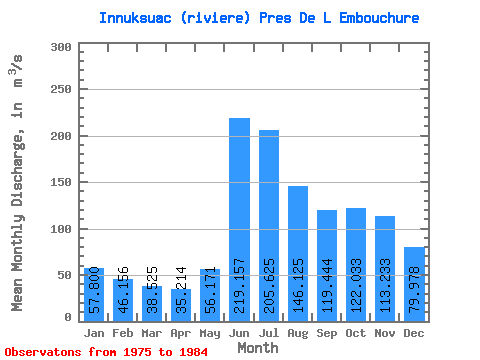
| Statistic | Jan | Feb | Mar | Apr | May | Jun | Jul | Aug | Sep | Oct | Nov | Dec | Annual |
|---|---|---|---|---|---|---|---|---|---|---|---|---|---|
| Mean | 57.80 | 46.16 | 38.52 | 35.21 | 56.17 | 219.16 | 205.62 | 146.12 | 119.44 | 122.03 | 113.23 | 79.98 | 100.21 |
| Standard Deviation | 7.60 | 7.61 | 6.79 | 6.77 | 34.25 | 76.14 | 57.28 | 41.96 | 26.75 | 22.66 | 24.43 | 12.54 | 15.12 |
| Min | 46.50 | 36.00 | 30.30 | 28.20 | 27.10 | 73.10 | 140.00 | 111.00 | 93.00 | 85.30 | 66.20 | 53.90 | 76.52 |
| Max | 65.80 | 57.10 | 49.50 | 46.70 | 127.00 | 314.00 | 286.00 | 215.00 | 176.00 | 159.00 | 152.00 | 97.60 | 123.81 |
| Coefficient of Variation | 0.13 | 0.17 | 0.18 | 0.19 | 0.61 | 0.35 | 0.28 | 0.29 | 0.22 | 0.19 | 0.22 | 0.16 | 0.15 |
 Return to R-Arctic Net Home Page