|
|
|||||||||||||||||
| Point ID: 5155 | Downloads | Plots | Site Data | Other Close Sites | Code: 03FC008 |
|
|
|||||||||||||||||
| Download | |
|---|---|
| Site Descriptor Information | Site Time Series Data |
| Link to all available data | |
| View: | Time Series | All |
| Units: | mm |
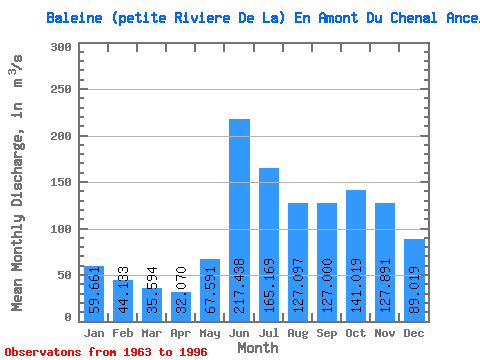
| Statistic | Jan | Feb | Mar | Apr | May | Jun | Jul | Aug | Sep | Oct | Nov | Dec | Annual |
|---|---|---|---|---|---|---|---|---|---|---|---|---|---|
| Mean | 59.66 | 44.13 | 35.59 | 32.07 | 67.59 | 217.44 | 165.17 | 127.10 | 127.00 | 141.02 | 127.89 | 89.02 | 102.92 |
| Standard Deviation | 6.93 | 5.03 | 4.29 | 4.46 | 34.14 | 39.91 | 34.71 | 34.91 | 37.69 | 34.83 | 26.86 | 12.97 | 9.36 |
| Min | 44.00 | 33.10 | 26.60 | 22.00 | 26.50 | 111.00 | 90.90 | 65.10 | 62.30 | 74.70 | 84.40 | 65.60 | 79.54 |
| Max | 74.30 | 55.70 | 45.80 | 40.00 | 166.00 | 286.00 | 247.00 | 221.00 | 205.00 | 213.00 | 191.00 | 123.00 | 118.45 |
| Coefficient of Variation | 0.12 | 0.11 | 0.12 | 0.14 | 0.51 | 0.18 | 0.21 | 0.28 | 0.30 | 0.25 | 0.21 | 0.15 | 0.09 |
| Other Close Sites | ||||||
|---|---|---|---|---|---|---|
| PointID | Latitude | Longitude | Drainage Area | Source | Name | |
| 5151 | "BALEINE (PETITE RIVIERE DE LA)" | 55.73 | -991273 | Hydat | ||
| 5153 | "BOUTIN (RIVIERE) A LA SORTIE DES LACS MOLLET-1" | 55.57 | -1006550 | Hydat | ||
| 5154 | "BOUTIN (RIVIERE) A LA SORTIE DES LAC MOLLET-2" | 55.57 | -1006550 | Hydat | ||
 Return to R-Arctic Net Home Page