|
|
|||||||||||||||||
| Point ID: 5150 | Downloads | Plots | Site Data | Code: 03FC002 |
|
|
|||||||||||||||||
| Download | |
|---|---|
| Site Descriptor Information | Site Time Series Data |
| Link to all available data | |
| View: | Time Series | All |
| Units: | mm |
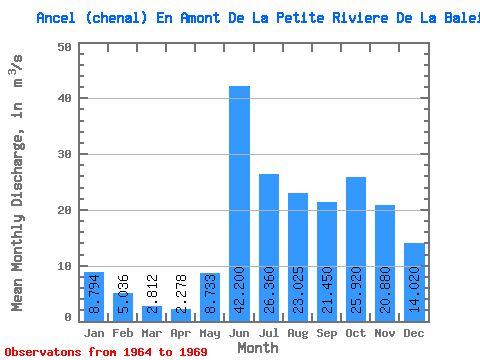
| Statistic | Jan | Feb | Mar | Apr | May | Jun | Jul | Aug | Sep | Oct | Nov | Dec | Annual |
|---|---|---|---|---|---|---|---|---|---|---|---|---|---|
| Mean | 8.79 | 5.04 | 2.81 | 2.28 | 8.73 | 42.20 | 26.36 | 23.02 | 21.45 | 25.92 | 20.88 | 14.02 | 16.44 |
| Standard Deviation | 2.88 | 1.35 | 1.18 | 1.03 | 5.17 | 7.44 | 6.45 | 5.27 | 6.03 | 7.52 | 5.42 | 3.69 | 2.53 |
| Min | 6.27 | 3.45 | 1.74 | 1.12 | 4.21 | 33.80 | 17.20 | 16.30 | 13.00 | 15.30 | 14.20 | 10.20 | 12.79 |
| Max | 13.20 | 6.69 | 4.55 | 3.36 | 16.10 | 51.90 | 35.00 | 27.80 | 26.30 | 35.50 | 28.20 | 18.60 | 18.52 |
| Coefficient of Variation | 0.33 | 0.27 | 0.42 | 0.45 | 0.59 | 0.18 | 0.24 | 0.23 | 0.28 | 0.29 | 0.26 | 0.26 | 0.15 |
 Return to R-Arctic Net Home Page