|
|
|||||||||||||||||
| Point ID: 5136 | Downloads | Plots | Site Data | Code: 03EC001 |
|
|
|||||||||||||||||
| Download | |
|---|---|
| Site Descriptor Information | Site Time Series Data |
| Link to all available data | |
| View: | Time Series | All |
| Units: | mm |
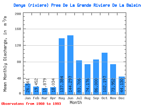
| Statistic | Jan | Feb | Mar | Apr | May | Jun | Jul | Aug | Sep | Oct | Nov | Dec | Annual |
|---|---|---|---|---|---|---|---|---|---|---|---|---|---|
| Mean | 26.56 | 19.45 | 15.88 | 18.03 | 137.38 | 144.30 | 83.71 | 74.18 | 86.00 | 102.20 | 73.95 | 44.13 | 69.00 |
| Standard Deviation | 4.41 | 3.06 | 2.96 | 11.60 | 49.12 | 47.98 | 29.74 | 30.93 | 31.18 | 31.71 | 18.61 | 10.03 | 9.49 |
| Min | 17.50 | 12.50 | 10.50 | 10.60 | 38.80 | 72.30 | 38.70 | 23.40 | 22.00 | 45.60 | 38.00 | 27.00 | 49.52 |
| Max | 38.20 | 25.50 | 22.70 | 73.00 | 236.00 | 263.00 | 181.00 | 153.00 | 147.00 | 168.00 | 125.00 | 69.40 | 84.62 |
| Coefficient of Variation | 0.17 | 0.16 | 0.19 | 0.64 | 0.36 | 0.33 | 0.35 | 0.42 | 0.36 | 0.31 | 0.25 | 0.23 | 0.14 |
 Return to R-Arctic Net Home Page