|
|
|||||||||||||||||
| Point ID: 5133 | Downloads | Plots | Site Data | Code: 03EA001 |
|
|
|||||||||||||||||
| Download | |
|---|---|
| Site Descriptor Information | Site Time Series Data |
| Link to all available data | |
| View: | Time Series | All |
| Units: | mm |
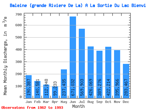
| Statistic | Jan | Feb | Mar | Apr | May | Jun | Jul | Aug | Sep | Oct | Nov | Dec | Annual |
|---|---|---|---|---|---|---|---|---|---|---|---|---|---|
| Mean | 190.39 | 140.58 | 112.05 | 99.23 | 237.44 | 671.03 | 569.90 | 426.07 | 389.28 | 422.21 | 395.97 | 283.47 | 335.97 |
| Standard Deviation | 30.27 | 22.97 | 19.52 | 18.08 | 118.72 | 185.05 | 163.26 | 136.79 | 127.39 | 88.71 | 91.28 | 54.78 | 47.27 |
| Min | 137.00 | 100.00 | 78.50 | 63.50 | 80.70 | 351.00 | 345.00 | 211.00 | 168.00 | 218.00 | 239.00 | 177.00 | 220.00 |
| Max | 254.00 | 193.00 | 161.00 | 151.00 | 600.00 | 1170.00 | 1040.00 | 838.00 | 700.00 | 579.00 | 612.00 | 402.00 | 436.59 |
| Coefficient of Variation | 0.16 | 0.16 | 0.17 | 0.18 | 0.50 | 0.28 | 0.29 | 0.32 | 0.33 | 0.21 | 0.23 | 0.19 | 0.14 |
 Return to R-Arctic Net Home Page