|
|
|||||||||||||||||
| Point ID: 5131 | Downloads | Plots | Site Data | Code: 03DF001 |
|
|
|||||||||||||||||
| Download | |
|---|---|
| Site Descriptor Information | Site Time Series Data |
| Link to all available data | |
| View: | Time Series | All |
| Units: | mm |
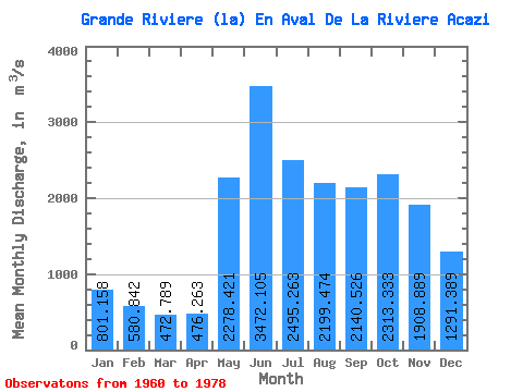
| Statistic | Jan | Feb | Mar | Apr | May | Jun | Jul | Aug | Sep | Oct | Nov | Dec | Annual |
|---|---|---|---|---|---|---|---|---|---|---|---|---|---|
| Mean | 801.16 | 580.84 | 472.79 | 476.26 | 2278.42 | 3472.11 | 2495.26 | 2199.47 | 2140.53 | 2313.33 | 1908.89 | 1291.39 | 1690.29 |
| Standard Deviation | 174.17 | 117.46 | 80.05 | 79.32 | 753.84 | 754.16 | 692.77 | 738.82 | 652.21 | 677.06 | 440.15 | 306.97 | 250.49 |
| Min | 553.00 | 383.00 | 345.00 | 355.00 | 1140.00 | 1790.00 | 1760.00 | 1130.00 | 1110.00 | 1230.00 | 1000.00 | 720.00 | 1255.58 |
| Max | 1190.00 | 872.00 | 690.00 | 639.00 | 4210.00 | 4640.00 | 4270.00 | 3500.00 | 3320.00 | 3630.00 | 2760.00 | 2030.00 | 2127.83 |
| Coefficient of Variation | 0.22 | 0.20 | 0.17 | 0.17 | 0.33 | 0.22 | 0.28 | 0.34 | 0.30 | 0.29 | 0.23 | 0.24 | 0.15 |
 Return to R-Arctic Net Home Page