|
|
|||||||||||||||||
| Point ID: 5107 | Downloads | Plots | Site Data | Code: 03CC002 |
|
|
|||||||||||||||||
| Download | |
|---|---|
| Site Descriptor Information | Site Time Series Data |
| Link to all available data | |
| View: | Time Series | All |
| Units: | mm |
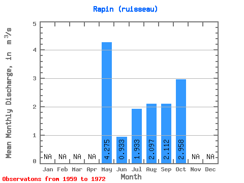
| Statistic | Jan | Feb | Mar | Apr | May | Jun | Jul | Aug | Sep | Oct | Nov | Dec | Annual |
|---|---|---|---|---|---|---|---|---|---|---|---|---|---|
| Mean | 4.28 | 0.93 | 1.93 | 2.10 | 2.11 | 2.96 | |||||||
| Standard Deviation | 2.23 | 1.39 | 1.26 | 0.98 | 1.25 | ||||||||
| Min | 2.70 | 0.93 | 0.47 | 0.75 | 0.64 | 2.10 | |||||||
| Max | 5.85 | 0.93 | 3.60 | 3.89 | 3.53 | 4.78 | |||||||
| Coefficient of Variation | 0.52 | 0.72 | 0.60 | 0.46 | 0.42 |
 Return to R-Arctic Net Home Page