|
|
|||||||||||||||||
| Point ID: 5079 | Downloads | Plots | Site Data | Code: 03AB001 |
|
|
|||||||||||||||||
| Download | |
|---|---|
| Site Descriptor Information | Site Time Series Data |
| Link to all available data | |
| View: | Time Series | All |
| Units: | mm |
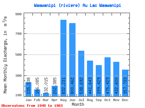
| Statistic | Jan | Feb | Mar | Apr | May | Jun | Jul | Aug | Sep | Oct | Nov | Dec | Annual |
|---|---|---|---|---|---|---|---|---|---|---|---|---|---|
| Mean | 235.54 | 166.09 | 132.01 | 202.38 | 832.23 | 800.46 | 538.69 | 441.64 | 399.43 | 475.43 | 432.60 | 357.73 | 425.77 |
| Standard Deviation | 62.51 | 40.27 | 32.91 | 149.33 | 189.68 | 231.22 | 156.86 | 172.47 | 141.30 | 128.02 | 111.33 | 91.14 | 57.35 |
| Min | 144.00 | 98.10 | 73.20 | 108.00 | 540.00 | 492.00 | 332.00 | 211.00 | 230.00 | 223.00 | 228.00 | 211.00 | 324.01 |
| Max | 363.00 | 254.00 | 187.00 | 680.00 | 1170.00 | 1230.00 | 810.00 | 758.00 | 626.00 | 715.00 | 660.00 | 527.00 | 520.50 |
| Coefficient of Variation | 0.27 | 0.24 | 0.25 | 0.74 | 0.23 | 0.29 | 0.29 | 0.39 | 0.35 | 0.27 | 0.26 | 0.26 | 0.14 |
 Return to R-Arctic Net Home Page