|
|
|||||||||||||||||
| Point ID: 501 | Downloads | Plots | Site Data | Code: 05EB902 |
|
|
|||||||||||||||||
| Download | |
|---|---|
| Site Descriptor Information | Site Time Series Data |
| Link to all available data | |
| View: | Time Series | All |
| Units: | mm |
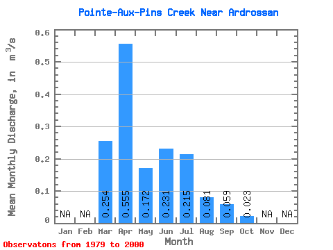
| Statistic | Jan | Feb | Mar | Apr | May | Jun | Jul | Aug | Sep | Oct | Nov | Dec | Annual |
|---|---|---|---|---|---|---|---|---|---|---|---|---|---|
| Mean | 0.25 | 0.56 | 0.17 | 0.23 | 0.21 | 0.08 | 0.06 | 0.02 | |||||
| Standard Deviation | 0.23 | 0.50 | 0.18 | 0.42 | 0.28 | 0.18 | 0.16 | 0.05 | |||||
| Min | 0.00 | 0.02 | 0.01 | 0.00 | 0.00 | 0.00 | 0.00 | 0.00 | |||||
| Max | 0.80 | 1.93 | 0.63 | 1.52 | 1.03 | 0.84 | 0.76 | 0.21 | |||||
| Coefficient of Variation | 0.92 | 0.90 | 1.07 | 1.84 | 1.28 | 2.29 | 2.77 | 2.29 |
 Return to R-Arctic Net Home Page