|
|
|||||||||||||||||
| Point ID: 500 | Downloads | Plots | Site Data | Code: 05EB016 |
|
|
|||||||||||||||||
| Download | |
|---|---|
| Site Descriptor Information | Site Time Series Data |
| Link to all available data | |
| View: | Time Series | All |
| Units: | mm |
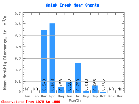
| Statistic | Jan | Feb | Mar | Apr | May | Jun | Jul | Aug | Sep | Oct | Nov | Dec | Annual |
|---|---|---|---|---|---|---|---|---|---|---|---|---|---|
| Mean | 0.54 | 0.60 | 0.05 | 0.10 | 0.26 | 0.02 | 0.06 | 0.01 | |||||
| Standard Deviation | 0.81 | 0.50 | 0.06 | 0.24 | 0.63 | 0.07 | 0.19 | 0.01 | |||||
| Min | 0.00 | 0.01 | 0.00 | 0.00 | 0.00 | 0.00 | 0.00 | 0.00 | |||||
| Max | 2.48 | 1.74 | 0.19 | 0.88 | 2.25 | 0.30 | 0.70 | 0.05 | |||||
| Coefficient of Variation | 1.49 | 0.83 | 1.09 | 2.43 | 2.46 | 3.64 | 2.95 | 2.30 |
 Return to R-Arctic Net Home Page