|
|
|||||||||||||||||
| Point ID: 50 | Downloads | Plots | Site Data | Code: 05AB032 |
|
|
|||||||||||||||||
| Download | |
|---|---|
| Site Descriptor Information | Site Time Series Data |
| Link to all available data | |
| View: | Time Series | All |
| Units: | mm |
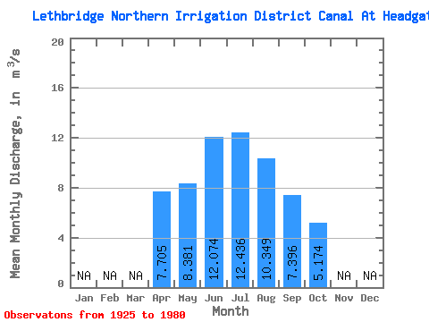
| Statistic | Jan | Feb | Mar | Apr | May | Jun | Jul | Aug | Sep | Oct | Nov | Dec | Annual |
|---|---|---|---|---|---|---|---|---|---|---|---|---|---|
| Mean | 7.71 | 8.38 | 12.07 | 12.44 | 10.35 | 7.40 | 5.17 | ||||||
| Standard Deviation | 1.21 | 4.68 | 5.42 | 5.93 | 3.68 | 2.83 | 1.15 | ||||||
| Min | 6.85 | 2.62 | 2.73 | 1.70 | 4.93 | 4.35 | 4.03 | ||||||
| Max | 8.56 | 15.60 | 17.60 | 17.40 | 14.50 | 12.20 | 7.10 | ||||||
| Coefficient of Variation | 0.16 | 0.56 | 0.45 | 0.48 | 0.35 | 0.38 | 0.22 |
 Return to R-Arctic Net Home Page